Right now in St. George, expect clear desert skies with the kind of dramatic temperature swing this region is known for: warm afternoons giving way to cool, dry evenings. The most recent observation from the local station shows conditions typical for the season, with any precipitation chance staying low unless a monsoon cell or winter storm system is moving through. If you’re heading out for a hike, a round of golf, or a drive to Zion this afternoon, current conditions and the next few hours matter more than anything else on this page.
That reading comes from the St. George Regional Airport (KSGU) automated station, which updates its METAR observations roughly every hour and feeds directly into the National Weather Service’s local forecast grids. For the live number before you walk out the door, check the current 7-day forecast for St. George directly from NWS, since conditions here can shift faster than a quick web search will show you.
- Temperature and feels-like: Desert humidity is usually low enough that the “feels-like” reading tracks close to the actual air temperature, except during rare summer humidity spikes tied to monsoon moisture.
- Precipitation chance: Confirm the hourly percentage on the NWS point forecast before committing to a canyon trail, especially July through September.
- Wind and gusts: Afternoon wind tends to pick up ahead of frontal passages or thunderstorm outflow; check gusts separately from sustained wind speed.
Pro Tip: Bookmark the KSGU station page and the NWS radar loop together. One tells you what’s happening at the airport right now; the other tells you what’s heading your way in the next hour.
For context on how today compares to normal, St. George’s period-of-record climate data puts December as the coldest month, with average lows dipping to around 26°F, while July highs average above 101°F. Whatever the thermometer reads today, that range tells you how far from “typical” you’re standing.
Key Takeaways
St. George’s weather swings from triple-digit summer heat to freezing winter nights, which means checking current conditions, the 10-day trend, and radar before finalizing any outdoor plan.
| Point | Details |
|---|---|
| Check the BLUF first | Confirm current temperature, precipitation chance, and wind from KSGU or the NWS point forecast before heading out. |
| Watch the hourly trend | Use hourly tables to time canyon hikes before afternoon monsoon storms typically build. |
| Respect the 7-10 day outlook | Treat days seven through ten as trend guidance and recheck closer to your travel date. |
| Pack for both extremes | December lows near 26°F and July highs above 101°F mean layering matters year-round. |
| Book weather-ready lodging | Rentalsinstgeorgeutah’s vacation rentals offer air conditioning, shaded patios, and flexible check-in for uncertain forecasts. |
Table of Contents
- What Will the Weather Do in the Next 24 Hours?
- How Will the Weather Trend Over the Next 7 to 10 Days?
- How Do You Read Radar and Satellite Maps for St. George?
- Which Weather Warnings Matter Most in St. George?
- What Is the Climate Like Across the Year?
- Should You Check Air Quality and UV Before Heading Out?
- Where Does This Forecast Data Actually Come From?
- How Do Local Hosts Plan Around St. George’s Weather?
- Planning a Stay Around St. George’s Weather?
- Where Can You Check Live Weather Updates?
- Sources
- FAQ
What Will the Weather Do in the Next 24 Hours?
The next 6 to 12 hours usually bring one of three patterns in St. George: steady clear skies with a predictable afternoon warmup, a fast-building monsoon cell that flares up and dies within a couple hours, or a winter frontal system that drops temperatures 15 to 20 degrees overnight. Knowing which pattern you’re in changes how you plan the rest of your day.
An hourly forecast table, whether from the NWS grid forecast or a weather app pulling that same data, should show six columns worth watching: hour, temperature, feels-like, precipitation chance, wind speed and direction, and a short condition icon. Read it left to right in blocks of two or three hours rather than hour by hour. Desert air changes gradually except when a storm cell is actively forming, so clumping the hours gives you a cleaner read on trends like “cooling steadily after 6 PM” or “precipitation chance rising sharply after 3 PM.”
| Hour Block | What to Watch | Typical Planning Move |
|---|---|---|
| Morning (6–10 AM) | Coolest temps, lowest UV, calmest wind | Best window for hikes and outdoor exercise |
| Midday (11 AM–3 PM) | Peak heat, highest UV, monsoon buildup begins | Move indoors or seek shade; watch radar |
| Afternoon (3–6 PM) | Highest thunderstorm risk in summer | Delay canyon or slot hikes until storms clear |
| Evening (6–8 PM) | Temps drop, wind often calms | Good window for dinner patios, short walks |
Pro Tip: During monsoon season, avoid starting a canyon hike after 1 PM. Storm cells that build over the plateau can dump heavy rain miles away and still send a flash flood down a wash that looks bone dry when you start out.
Precipitation timing during an active pattern typically follows a loose script: onset within a two to three hour window as afternoon heating builds convection, a burst lasting 20 to 45 minutes, and fading confidence beyond about six hours out since these cells are notoriously hard to pin to an exact street or trailhead. The NWS local point forecast blends short-range models with real-time KSGU observations, which is why checking it again an hour before you leave beats relying on a forecast you checked that morning.
How Will the Weather Trend Over the Next 7 to 10 Days?
The headline for any multi-day stretch in St. George almost always falls into one of four buckets: sustained heat, a cooling trend behind a frontal system, an unsettled monsoon pattern with scattered afternoon storms, or a quiet, stable stretch with wide clear skies. Multi-day trip planning depends far more on which bucket you’re in than on the exact high temperature for day six.
- Days 1 to 3: Highest forecast confidence; expect day-by-day highs and lows close to what the NWS grid shows now.
- Days 4 to 6: Moderate confidence; watch for a shift from “sunny and dry” to “chance of afternoon storms” if monsoon moisture pushes in from the south.
- Days 7 to 10: Lower confidence; treat these as trend guidance rather than a locked forecast, and recheck closer to your travel date.
Sustained triple-digit heat typically settles in from June through August, with July averaging highs above 101°F. Monsoon thunderstorm activity usually peaks from mid-July through September, arriving as fast-forming, short-lived storms rather than the all-day rain more common in other parts of the country. If a 7-day outlook shows a NWS watch already flagged for days three or four, treat that as a stronger signal than an advisory tucked quietly into the text forecast. For canyon hikes or slot canyon tours, schedule them on days the outlook shows low thunderstorm probability, and build in a backup morning in case the forecast shifts.
How Do You Read Radar and Satellite Maps for St. George?
The most useful live tools for this area are the NWS regional radar loop, a regional composite radar that stitches together multiple stations for a wider view of approaching systems, and a satellite cloud cover loop that shows moisture streaming in from the south during monsoon season. Together they answer two different questions: radar shows what’s raining right now, and satellite shows what’s coming in the next few hours.
On radar, watch for fast-moving convective echoes that pop up suddenly over higher terrain and drift toward town, bowing line segments that signal strong outflow winds, and deep red or purple returns that indicate the heaviest rain rates. A small, intense cell over a distant plateau can still be the reason a wash near your trailhead floods 30 minutes later.
Pro Tip: St. George’s canyon and mesa terrain slows and redirects storm motion compared to open desert. A cell that looks like it’s tracking away from town on radar can still stall against a ridge and dump rain into a drainage that empties right where you’re hiking. Always check the storm’s actual motion vector, not just its current position.
Open these three before heading out: the NWS local radar, a regional composite view for the wider southern Utah picture, and a satellite loop to see what’s still building upstream. Where radar overlays include flash-flood guidance, a wash or canyon highlighted in that layer is a hard no for hiking that day, regardless of how clear the sky looks overhead.
Which Weather Warnings Matter Most in St. George?
The three NWS products that matter most locally are the Flash Flood Warning, the Severe Thunderstorm Warning, and the Excessive Heat Warning, each carrying a different level of urgency. A watch means conditions are favorable and you should stay alert; a warning means the hazard is happening or imminent and you need to act now; an advisory covers a lesser but still notable inconvenience or hazard.
- Flash Flood Warning: Get out of washes, slot canyons, and low-lying trails immediately, even if the sky above you is clear.
- Severe Thunderstorm Warning: Move off exposed ridgelines and open water, and postpone river or boating trips.
- Excessive Heat Warning: Shift outdoor plans to early morning, increase water intake, and check on anyone without reliable air conditioning.
Monitor the local NWS office’s alert page, push alerts through your phone’s built-in weather warnings, and cross-check current METAR readings from KSGU when you want a fast, no-frills confirmation of what’s happening right now. A familiar local scenario: a monsoon cell builds over the plateau in early afternoon, drops heavy rain for 20 minutes, and a Flash Flood Warning goes out for a specific wash even though downtown St. George never sees a drop.
What Is the Climate Like Across the Year?
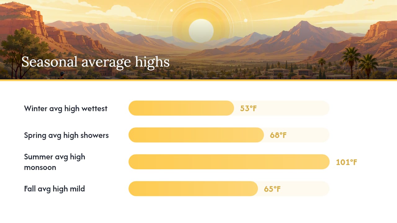
December is St. George’s coldest month, with average lows near 26°F and overnight temperatures that regularly touch freezing, according to long-term station data. On the other end, July and August bring the year’s most intense heat, with July averaging highs above 101°F and August close behind at 99.5°F.
| Season | Avg High | Avg Low | Precipitation Note |
|---|---|---|---|
| Winter (Dec–Feb) | 53°F | 26°F | Wettest stretch of the year, occasional rain/snow mix |
| Spring (Mar–May) | 68°F | 38°F | Light, scattered showers |
| Summer (Jun–Aug) | 101°F | 65°F | Dry early summer, monsoon storms late July–September |
| Fall (Sep–Nov) | 65°F | 40°F | Mild, generally dry with occasional monsoon tail |
Snow rarely sticks in St. George itself thanks to its lower elevation, though surrounding higher terrain can pick up meaningful accumulation the same week the valley floor stays dry. Winter and the late-summer monsoon are actually the wettest stretches of the year here, so a rain-free winter visit isn’t a safe assumption.
Spring and fall stand out as the sweet spot for outdoor plans, with daytime highs typically running 65°F to 85°F and far less risk of the flash-flood-triggering storms that show up in July and August. Mid-summer travel isn’t off the table, but it means planning around the heat rather than ignoring it.
Should You Check Air Quality and UV Before Heading Out?
Yes, check both before finalizing outdoor plans, especially between May and September when UV exposure and heat stack on top of each other. Local air quality tends to stay in the moderate range most of the year but can spike during wildfire season in the broader region, so a quick AQI check takes seconds and saves a wasted afternoon for anyone with asthma or another respiratory condition.
- On high-AQI days, shorten outdoor exertion and avoid strenuous exercise between late morning and mid-afternoon.
- Schedule outdoor time for early morning or evening in summer, when both UV and heat are lower.
- Use SPF 30 or higher, a wide-brim hat, and lightweight long sleeves during midday between June and August.
- Reapply sunscreen every two hours if you’re near water or sweating heavily.
Summer UV in St. George frequently reaches the “Extreme” category (11+), which means sunburn risk climbs fast even on a partly cloudy day.
Pro Tip: Evenings in July and August often stay above 75°F, so the “cooling off” you’re expecting after sunset may not arrive for hours. Plan indoor recovery time or a pool break rather than assuming dusk will bring quick relief.
Where Does This Forecast Data Actually Come From?
Every figure on this page traces back to three sources: the National Weather Service and NOAA for live observations, radar, and forecast grids; the local ASOS station at St. George Regional Airport (KSGU) for hourly ground-truth readings; and NOAA’s National Centers for Environmental Information for the 1991-2020 climate normals that anchor seasonal comparisons.
NOAA operates the radar network and issues the watches and warnings that matter most for outdoor safety here, while KSGU’s automated sensors report temperature, wind, and precipitation in near real time. The NCEI normals dataset is what makes a statement like “today is 8 degrees above normal” meaningful rather than a guess.
Forecast timestamps matter because NWS grids typically refresh multiple times per day, while KSGU observations update roughly hourly. A forecast checked at breakfast can be stale by mid-afternoon if a storm cell has since developed.
Station KSGU, St. George Regional Airport, sits at approximately 2,941 feet elevation and serves as the primary automated weather reporting point for the entire St. George area.
How Do Local Hosts Plan Around St. George’s Weather?
Rental hosts across St. George think about weather almost year-round, not just during obvious extremes. Summer prep means confirming air conditioning is running efficiently well before the first 100°F day and making sure shaded patio space is usable during the brutal midday hours. Monsoon season shifts the focus toward guest communication: a quick note about avoiding nearby washes during active storm warnings goes a long way toward preventing a scary situation on a slot canyon trail.

Winter is its own planning exercise. Desert nights swing hard even when the daytime high looks mild, so reliable heating and warm bedding matter as much in a St. George rental as they would somewhere with actual snow on the ground. A few habits worth borrowing whether you’re staying in a rental or not: check the forecast the morning of any canyon trip, pack layers for the day-to-night temperature swing, and push strenuous outdoor activity to the morning hours whenever a heat advisory is in play.
Planning a Stay Around St. George’s Weather?
Whatever the forecast shows for your trip, the right home base takes the guesswork out of dealing with it. A vacation rental with dependable central air and a shaded patio makes a 105°F July afternoon a non-issue, and a home with strong heating and thick bedding turns a chilly December night into a cozy one instead of a scramble for extra blankets.

Rentalsinstgeorgeutah’s vacation homes in St. George are selected with this exact climate in mind: private patios positioned for shade, full kitchens so you’re not stuck driving through midday heat for meals, and proximity to Zion National Park for easy day trips once the forecast clears. If a monsoon system or a cold front threatens to reshuffle your plans, flexible check-in and customizable stay options make it easy to adjust your arrival or departure without losing your reservation.
Browse current home rental deals in St. George and pick a property with the amenities that match your travel season, whether that’s a private pool for summer heat or a fireplace-equipped living room for a winter getaway.
Where Can You Check Live Weather Updates?
- NWS 7-day and hourly grid forecast: The most authoritative source for point-specific forecasts near St. George, updated multiple times daily.
- NCEI climate normals: Official 1991-2020 monthly averages for comparing today’s weather to what’s typical.
- Local METAR/KSGU observations: Hourly ground-truth readings straight from St. George Regional Airport.
- NWS radar loop: Live precipitation tracking for spotting fast-building monsoon cells.
- Satellite cloud cover loop: Shows incoming moisture before it reaches the radar’s range.
Open at least two of these, ideally the radar and the hourly forecast, before leaving for any outdoor plan during monsoon season or a winter storm pattern.
Sources
FAQ
What Is the Coldest Month in St. George, Utah?
December is the coldest month, with an average low near 26°F and overnight temperatures that regularly reach freezing between December and February.
How Much Snow Does St. George Get?
St. George receives very little snow in town, and any accumulation typically melts within hours, though higher surrounding terrain nearby can see significant snowfall in the same week.
What Is the Best Month to Visit St. George, Utah?
Spring (March through May) and fall (late September through November) offer the best conditions, with daytime highs typically between 65°F and 85°F and lower flash-flood risk than peak monsoon season. If you’re booking a stay during these shoulder seasons, flexible rental options make it easy to shift dates if a system moves through.
Is St. George, Utah Warm All Year?
Not entirely. Summers bring intense heat with July highs averaging above 101°F, but winter nights regularly drop to freezing, and the region sees its wettest stretches in winter and during the late-summer monsoon.
How Often Does the St. George Forecast Update?
NWS forecast grids typically refresh several times a day, while the KSGU automated station updates hourly observations, so rechecking closer to your outdoor activity gives you the most accurate picture.